


Spain Topo Maps

Spain Topo Mapsの説明
+++新しいGPSマッピングアプリ+++
スペインのための最高の地形図と航空写真へのアクセス権を持つ屋外/オフラインGPSナビゲーションアプリを使いやすい。
バレアレス諸島とカナリア諸島を含む
++オフラインの場合はPRO機能が必要です。 ++
セルカバレッジなしでバックカントリーへの旅行のための屋外のGPSにあなたのAndoid Phone / Tabletを回してください。あなたはGPSハンドヘルドからあなたが知っているかもしれないように、このアプリはあなたに類似のマッピングオプションを与えます。
無料の地図レイヤーが含まれています。
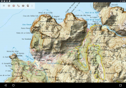
•スペインTopo Map:MapaTopográficoNacional 1:50.000&1:25.000(IGN MTN25&MTN50)
•IGNベースマップ:Base Topografica Nacional 1:25.000(BTN25&BCN25)
•スペインの画像:高解像度の航空画像。 OrtofotografíaAérea(PNOA)を計画します。
•カタルーニャトポマップ:カタルーニャの高解像度地形図
•土地登記図:CartografíaCatastral
•OpenStreetMaps:これらのクラウドソースマップは、他のマップレイヤに非常に便利な追加機能です。多くのユニークな機能が含まれています。
•OpenCycleMaps:これらのマップは自転車旅行を計画するのに理想的です。
•ESRIの地形
•ESRIの航空写真
•ESRIストリートマップ
•Googleロードマップ(オンラインアクセスのみ)
•Google Satellite Images(オンラインアクセスのみ)
•Google Terrain Map(オンラインアクセスのみ)
•Bingロードマップ(オンラインアクセスのみ)
•Bing衛星画像(オンラインアクセスのみ)
•夜の地球
•ヒルシェードオーバーレイ
屋外ナビゲーションの主な機能:
•ウェイポイントの作成と編集
•GoTo-Waypoint-Navigation
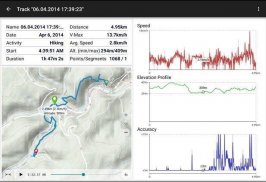
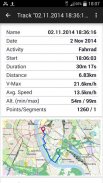
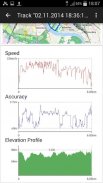
•トラックレコーディング(速度、高度、精度プロファイル付き)
走行距離計、平均速度、方位、標高などのフィールドを持つTripmaster
•GPX / KML / KMZエクスポート
•検索(地名、施設、街路)
•マップビューとトリップマスターのカスタマイズ可能なデータフィールド(例:速度、距離、コンパスなど)
•ウェイポイント、トラックまたはルートの共有(Eメール、Whatsapp、Dropbox、Facebookなどを介して)
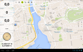
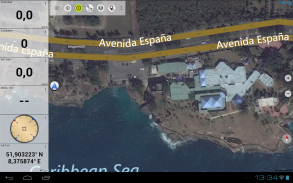
•緯度/経度、UTMまたはMGRS / USNG(ミリタリーグリッド/ USナショナルグリッド)で座標を表示
•統計と標高プロファイルでトラックを録音して共有
•地図を回転させる(トラックアップ&ノースアップ)
•地図をロングクリックして標高を取得
•トラックリプレイ
• などなど ...
利用可能なProの機能:(アプリ内課金で利用可能なProの機能)
•オフライン使用 - セルカバレッジは不要
•オフライン使用のためのマップタイルのEasy + Fast一括ダウンロード(GoogleおよびBingマップではありません)
ルートの作成と編集
ルートナビゲーション(ポイントツーポイントナビゲーション)
•GPX / KML / KMZのインポート
•無制限のウェイポイント&トラック
•他のMap Tile-Serverを追加する
• 広告なし
オフラインでの使用:
表示されているすべての地図タイルはキャッシュに保存されます。広い領域をキャッシュするには、Pro機能を購入する必要があります。
ハイキング、サイクリング、キャンプ、登山、乗馬、スキー、カヌー、狩猟、オフロード4WDツアー、捜索救助(SAR)などの屋外アクティビティにこのナビゲーションアプリを使用します。
WGS84測地基準系を使用して、経度/緯度、UTMまたはMGRS / USNG形式のカスタムウェイポイントを追加します。
GPXまたはGoogle Earth KML / KMZ形式でのインポート/エクスポート/共有のGPSウェイポイント/トラック/ルート。
携帯電話サービスのない地域の無料地図データをプリロードします(Pro機能!)。
spainmaps@atlogis.comへのコメントと機能追加
当社の他の屋外ナビゲーションアプリをご覧ください。https://play.google.com/store/search?q=atlogis
+++私たちは、ユーザーの行動を追跡したり、ユーザーデータを収集したりしません。 +++
Spain Topo Maps - バージョン 7.7.0
(20-02-2025)
Spain Topo Maps- APK情報
APKバージョン: 7.7.0パッケージ: com.atlogis.spainSpain Topo Mapsの最新バージョン
他のバージョン


同じカテゴリのアプリ


